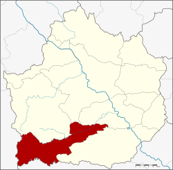
Pang Sila Thong district
Pang Sila Thong
ปางศิลาทอง | |
|---|---|
 District location in Kamphaeng Phet province | |
| Coordinates: 16°5′48″N 99°29′24″E / 16.09667°N 99.49000°E | |
| Country | Thailand |
| Province | Kamphaeng Phet |
| Seat | Pho Thong |
| Area | |
| • Total | 480.5 km2 (185.5 sq mi) |
| Population (2005) | |
| • Total | 30,591 |
| • Density | 63.7/km2 (165/sq mi) |
| Time zone | UTC+7 (ICT) |
| Postal code | 62120 |
| Geocode | 6209 |
Pang Sila Thong (Thai: ปางศิลาทอง, pronounced [pāːŋ sì.lāː tʰɔ̄ːŋ]) is the southwesternmost district (amphoe) of Kamphaeng Phet province, central Thailand.
History
[edit]The government split tambons Pang Ta Wai, Hin Dat, and Pho Thong from Khlong Khlung district and created the minor district (king amphoe) Pang Sila Thong on 31 May 1993.[1] It was upgraded to a full district on 11 October 1997.[2]
The name Pang Sila Thong stands for the three tambons comprising the district: Pang for Pang Ta Wai, Sila for Hin Dat and Thong for Pho Thong.
Geography
[edit]Neighboring districts are (from the north clockwise): Khlong Lan, Khlong Khlung, Khanu Woralaksaburi of Kamphaeng Phet Province; Mae Wong of Nakhon Sawan province and Umphang of Tak province.
Administration
[edit]The district is divided into three subdistricts (tambons), which are further subdivided into 42 villages (mubans). There are no municipal (thesaban) areas. There are three tambon administrative organizations (TAO).
| No. | Name | Thai name | Villages | Pop. | |
|---|---|---|---|---|---|
| 1. | Pho Thong | โพธิ์ทอง | 17 | 11,729 | |
| 2. | Hin Dat | หินดาต | 14 | 10,665 | |
| 3. | Pang Ta Wai | ปางตาไว | 11 | 8,197 |
References
[edit]- ^ ประกาศกระทรวงมหาดไทย เรื่อง แบ่งเขตท้องที่อำเภอคลองขลุง จังหวัดกำแพงเพชร ตั้งเป็นกิ่งอำเภอปางศิลาทอง (PDF). Royal Gazette (in Thai). 110 (74 ง): 14. June 8, 1993. Archived from the original (PDF) on March 9, 2012.
- ^ พระราชกฤษฎีกาตั้งอำเภอหนองปรือ อำเภอห้วยกระเจา อำเภอทรายทองวัฒนา อำเภอปางศิลาทอง อำเภอเนินสง่า อำเภอนาทม อำเภอพระพรหม อำเภอแม่วงก์ อำเภอสองแคว อำเภอบ้านใหม่ไชยพจน์ อำเภอไทยเจริญ อำเภอกาบัง อำเภอพยุห์ อำเภอเมืองจันทร์ อำเภอภูพาน อำเภอคลองหอยโข่ง อำเภอเขาฉกรรจ์ อำเภอนาวัง อำเภอพิบูลย์รักษ์ และอำเภอทุ่งศรีอุดม พ.ศ. ๒๕๔๐ (PDF). Royal Gazette (in Thai). 114 (50 ก): 24–27. September 26, 1997. Archived from the original (PDF) on January 27, 2012.
External links
[edit]
